KNEC KCSE Geography Paper 2 – 2014 KCSE COMA Joint Exam
2014 KCSE COMA Joint Exam
Geography Paper 2
SECTION A (25 Marks)
Answer all the questions in this section .
(a) Name three types of coral reefs. (3 mks)
(b) What are the benefits of coral reefs in the areas they have developed? (2 mks)
5 marks
(a) The diagram below represents features of intrusive vulcanicity.Name the features marked P,Q and R (3mks)
(b) How is a caldera formed? (2mks)
5 marks
(a) Name the three main layers of the atmosphere from the earth’s surface upwards. (3mks)
(b) What is temperature inversion? (2mks)
5 marks
(a) Highlight any three factors that necessitate the occurrence of an artesian basin. (3mks)
(b) Apart from lakes rivers and sea, name any other two sources of underground water. (2mks)
5 marks
Below is a diagram showing the structure of the atmosphere.
(a) Name the parts labeled a, b, and d. (3 mks)
(b) State the reasons for the behavior of graph at zones b and c. (2 mks)
5 marks
SECTION B (75 Marks)
Answer question Six and any other two questions from this section.
(a) Study the map of Nkubu provided and answer the questions that follow.
(i) Give the six figure grid reference of the road junction at Nkubu shopping centre. (1 mk)
(ii) What is the approximate height of Rurie swamp from the North East of the map? (1 mk)
(iii) What is the magnetic declination at the time the map was being drawn? (1mk)
(b) (i) Calculate the bearing of the Air photo principal point at Kaguma Grid square 4698 from the
trigonometrical station ( Grid square 5294) North of Thingithu River. (2 mks)
(ii) With evidence from the map identify three economic activities that the local people of
Nkubu engage in. (6 mks)
(c) (i) Describe the relief of the area covered by the map. (5 mks)
(ii) Explain three factors influencing settlement in the area covered by the map. (6mks)
(d) (i) Name the adjoining map extract to the East of Nkubu. (1 mk)
(ii) Calculate the area covered by the forest to the West of the map. (2 mks)
25 marks
(a) (i) Define wind abrasion. ( 2mks)
(ii) Name two processes of wind transportation. (2 mks)
(b) Give one difference between a rock pedestal and a mushroom block. (2 mks)
(c) (i) Explain a factor that makes wind an effective agent of erosion in arid areas. (2mks)
(ii) Give three characteristics of barchans. (3mks)
(d) Using well illustrated diagrams, explain how Mesas and Buttes form. (8mks)
(e) You are to carry out a field study in the arid north of Kenya:
(i) Mention three preparations you would make before the study. (3mks)
(ii)Mention three problems you are likely to face during the field study. (3mks)
25 marks
(a) (i) Define natural vegetation (1mk)
(ii) State four characteristics of national vegetation found in tropical rain forests (4mks)
(b) Explain four ways in which vegetation found in arid areas adapts to environmental conditions of
the region (8mks)
(c) Write the names of the grasslands found in the following areas (3mks)
(i) East Africa
(ii) Canada
(iii) Argentina
(d) (i) Give two reasons why Tundra region has scanty vegetation (2mks)
(ii)State two topographical factors that influence vegetation distribution (2mks)
(e) State five economic importance of vegetation (5mks)
25 marks
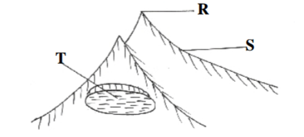
(a) The diagram below shows a glaciated upland area.
(i) Name the features marked R, S and T. (3mks)
(ii) Describe the distinctive characteristics of a fiord. (2mks)
(b) With the aid of well labelled diagrams, describe how the following features are formed:-
(i) Cirque (6mks)
(ii) A hanging valley (4mks)
(c) Explain two factors that may lead to glacial erosion in upland areas. (4mks)
(d) Suppose you were to carry out a field study on aglaciated upland.
(i) Name two types of moraine you are likely to identify. (2mks)
(ii) Give four reasons why you would need the map of the area. (4mks)
25 marks
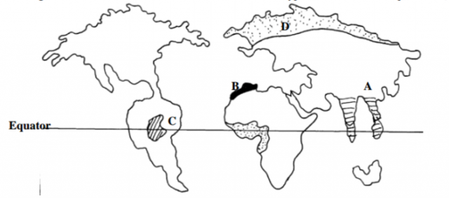
The diagram below shows the world distribution of climate types .Use it to answer questions (a)(i)and(ii)
(a) (i) Name the climatic Regions marked A,B and D. (4mks)
(ii) State any four characteristics of the climate marked C (4mks)
(b) (i) Identify any three types of cold climates. (3mks)
(ii) Briefly explain microclimate. (4mks)
(c) (i) What is climate change? (2mks)
(ii) Study the table below and use it to answer questions (a), (b) and (c)
Station Y
| Months | Jan | Feb | Mar | Apr | May | June | July | Aug | Sept | Oct | Nov | Dec |
| Temperature (0C) | 28 | 28 | 27 | 26 | 23 | 21 | 21 | 21 | 23 | 26 | 26 | 27 |
| Rainfall(mm) | 277 | 213 | 256 | 107 | 56 | 33 | 31 | 28 | 20 | 132 | 135 | 234 |
(a) Calculate the mean annual temperature for the station. (2mks)
(b) What is the mean annual rainfall. (2mks)
(c) State any one characteristics of the type of climate in the station. (2mks)
(d) (i) Explain any two causes of global warming. (4mks)
(ii) Name any one greenhouse gases. (1mk)
25 marks


