KNEC KCSE Geography Paper 1 / 2015 KCSE Kajiado County Joint Examination
2015 KCSE Kajiado County Joint Examination
Geography Paper 1
SECTION A (25 Marks)
Answer ALL the questions in this section
a) State two reasons why the interior of the earth is very hot. (2 marks)
b) Name the two dominant minerals in the continental crust. (2 marks)
4 marks
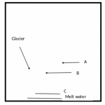
Explain how a moraine -dammed lake is formed.
4 marks
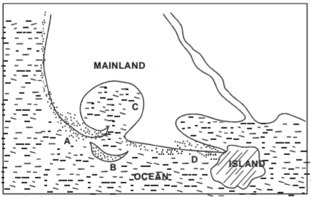
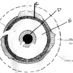
The diagram below shows features formed through wave deposition. Name the coastal features marked A, B, C and D. (4 marks)
b) State two causes of vertical movement of ocean water. (2 marks)
6 marks
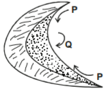
a) The diagram below shows a barchain.
i) Name the feature marked P. (1 mark)
ii) Name the air current marked Q. (1 mark)
iii) Identify the wind process that forms a barchan. (1 mark)
b) State three factors that contribute to the development of deserts. (3 marks)
6 marks
a) What is climate (2 marks)
b) Describe three characteristics of the Mediterranean type of vegetation. (3 marks)
5 marks
SECTION B (75 Marks)
Answer question 6 and any other two questions in this section
Study the map of Migwani 1:50,000 (sheet 151/1) provided and answer the following questions.
a) i) What is the six figure grid reference of Mui Dispensary in the east part of the area covered by the map. (2 marks)
ii) What was the magnetic declination of the area covered by the map as at January 1970. (1 mark)
b) i) Measure the length of the Dry weather Road (D502) from the junction in grid square 9278 to its junction with Road and
Track near Kamutungu school in Grid Square 9879. Give your answer in kilometres. (2 marks)
ii) What is the direction of the drift in Grid square 1271 from Holoni Dm in Grid square 9478. (1 mark)
iii) What is the altitude of the highest contour in the area covered by the map. (1 mark)
c) i) Using a scale of 1cm to represent 40m, draw a cross section along 80 between Eastings 03 and 12. (4 marks)
ii) On the cross section, mark and name the following:
– Hill (1 mark)
– Plain (1 mark)
– River Ngoo (1 mark)
iii) Calculate the vertical exaggeration (V.E) of the cross section. (1 mark)
d) i) Citing evidence from the map, explain three effects of relief on the construction of transport lines. (4 marks)
ii) Citing evidence from the area covered by the mp, give two economic functions of Gwani town in Grid square 9079.
(2 marks)
e) Describe the long profile of River Ikoo. (4 marks)
5 marks
a) i) Apart from humus, name three other components of soil. (3 marks)
ii) Differentiate between soil profile and soil catena. (2 marks)
iii) Name the four processes of soil formation. (4 marks)
b) i) What is soil degeneration? (2 marks)
ii) Explain how the following factors causes soil degeneration:
– Overgrazing (3 marks)
Heavy rainfall (4 marks)
c) i) State three characteristics of azonal soils. (3 marks)
ii) Explain how each of the following factors influence soil formation:
• Parent rock (2 marks)
• Living organisms (2 marks)
5 marks
a) i) What is a watershed? (2 marks)
ii) Differentiate between river capture and river rejuvenation. (2 marks)
iii) Apart from bird foot delta name other two types of marine delta. (2 marks)
b) i) Explain the four processes of erosion by a river. (8 marks)
ii) State five ways through which a waterfall is formed. (5 marks)
c) You are planning to carry out a field study on the upper course of a river.
i) Give two activities you are likely to engage in the preparation for the field study. (4 marks)
ii) State two characteristics of a river at the youthful stage you are likely observe during the field study. (3 marks)
iii) Give two methods of collecting data you are likely to use during the field study. (4 marks)
25 marks
a) i) Apart from the Atlas mountain, name two other fold mountains in Africa. (2 marks)
ii) What is orogenesis? (2 marks)
iii) Name the four orogenies known in geological history. (4 marks)
b) With the aid of labelled diagrams describe the formation of an overthrust fold. (8 marks)
c) i) Differentiate between symmetrical and asymmetrical folds. (3 marks)
ii) Explain three ways in which fold mountains influence human activities. (6 marks)
25 marks
a) i) State three physical conditions that are necessary for siting a weather station. (3 marks)
ii) Give four reasons why weather forecasting is important. (4 marks)
The table below shows rainfall and temperature figures of a station in Africa use it to answer questions b, c and d.
| Month | J | F | M | A | M | J | J | A | S | O | N | D |
| Temp o C | 24 | 24 | 23 | 22 | 19 | 17 | 17 | 18 | 19 | 20 | 22 | 23 |
| Rainfall in mm | 109 | 122 | 130 | 76 | 52 | 34 | 28 | 38 | 70 | 108 | 121 | 120 |
i) On the graph paper provided, draw a simple line graph to represent the temperature figures. (Use vertical scale of 1cm to represent 2.5°C) (5 marks)
ii) Calculate:
a) The mean annual rainfall in the station. (2 marks)
b) The annual range of temperature for the station. (2 marks)
c) Describe the climatic characteristics experienced in the above weather station. (3 marks)
d) Your Geography class intends to conduct a field study in a weather station.
i) State two methods you are likely to use to collect data. (2 marks)
ii) State three advantages of studying weather through fieldwork. (2 marks)
iii) Identify two methods you may use to present your findings. (2 marks)
25 marks
