KCSE Geography Paper 1 – Kabarak High School Mock 2015
Mock 2015 – Kabarak High School
Geography Paper 1
SECTION A (25 Marks)
Answer ALL the questions in this section
(a) State two reasons why Geography is a unique subject. (2 mks)
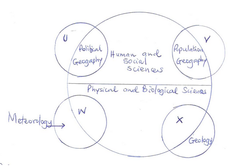
(b) The diagram below shows the relationship between geography and other disciplines.
Name the disciplines marked U, V, W and X. (4 mks)
6 marks
(a) If a given parcel of air at 350C contains 15.5 gm/m3 of moisture and the given air can hold a maximum of 20 gm/m3 at the same temperature, calculate the relative humidity. (2 mks)
(b) Draw a well labelled diagram to illustrate a mercury Barometer. (3 mks)
5 marks
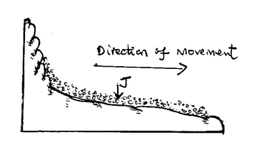
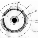
(a) Study the diagram below showing mass wasting.
- Name the mass wasting process in the diagram. (1 mk)
- Name the part marked J. (1 mk)
(b) State three effects of this process on the landscape. (3 mks)
5 marks
(a) Define a lake. (2 mks)
(b) State three effects of a lake on the climate of the surrounding areas. (3 mks)
5 marks
(a) Name two surface features found in a Karst region. (2 mks)
(b) State three conditions necessary for the formation of a Karst scenery. (3 mks)
5 marks
SECTION B (75 Marks)
Answer question 6 and any other TWO questions in this section.
Study the map of Kitale 1:50,000 (sheet 75/3) provided and answer the following questions.
(a) (i) Name two districts found in the area covered by the map. (2 mks)
(ii) What is the magnetic variation of the map? (1 mk)
(b) (i) Convert the scale of the map into a statement scale. (2 mks)
(ii) Calculate the area of land to the North and North East of the Loose Surface road C637 and B10/2 in the North Eastern corner of the map. (Give your answer in square kilometers). (2 mks)
(iii) Measure the distance of the Loose Surface Road C638 from grid reference 400137 and reference 472106. (Give your answer in Kilometres). (2 mks)
(c) Explain three factors which have influenced the distribution of settlements in the area covered by the map. (6 mks)
(d) Describe the relief of the area covered by the map. (4 mks)
(e) Citing evidence from the map, explain three factors that favour cattle rearing in Kitale area. (6 mks)
25 marks
(a) (i) What is faulting? (2 mks)
(ii) Apart from normal fault and reversed faults, name three other types of faults. (3 mks)
(b) (i) Apart from tensional forces, explain two other causes of faulting. (4 mks)
(ii) With the aid of well-labeled diagrams, describe how a rift valley was formed by tensional forces. (8 mks)
(c) Explain four effects of faulting on drainage. (8 mks)
25 marks
(a) Explain how the following factors influence the distribution of vegetation.
(i) Climate (2 mks)
(ii) Human beings (2 mks)
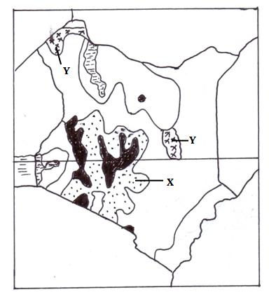
(b) The map below shows some vegetation zones of Kenya. Use it to answer question (i).
(i) Name the vegetation zone marked X and Y. (2 mks)
(ii) Give two uses of Savannah vegetation. (2 mks)
(iii) Describe the characteristics of Mediterranean type of vegetation. (5 mks)
(c) Explain three ways in which desert vegetation adapts to climatic conditions. (6 mks)
(d) You are planning to carry out a field study of the vegetation within the local environment.
(i) State three preparations you will make for the field study. (3 mks)
(ii) How will you identify the different types of vegetation? (3 mks)
25 marks
(a) (i) Distinguish between river discharge and river regime. (2 mks)
(ii) Describe how a river erodes through the following processes:-
- Abrasion (3 mks)
- Solution (2 mks)
(b) Describe how the following features are formed:
(i) Gorge, when a waterfall retreat (4 mks)
(ii) River braids (4 mks)
(c) State four characteristics of a river in the old stage. (4 mks)
(d) Explain three significance of a river to human activities. (6 mks)
25 marks
(a) What is soil profile? (1 mk)
(b) The diagram below shows a soil catena.
- Name the type of soils found in position R and U. (2 mks)
- State two characteristics of soils found in section marked.
- R (2 mks)
- U (2 mks)
(c) (i) Name two components of soil. (2 mks)
(ii) Differentiate between soil structure and soil texture. (2 mks)
(d) Explain how the following factors influence soil formation.
(i) Climate (4 mks)
(ii) Vegetation (4 mks)
(e) Explain how the following practices cause soil degeneration.
Burning (2 mks)
Leaching (2 mks)
Over-application of fertilizers (2 mks)
25 marks
