KNEC Geography Paper 1 Question Paper / 2016 KCSE MOKASA Joint Examination
2016 KCSE MOKASA Joint Examination
Geography Paper 1
SECTION A (25 Marks)
Answer all the questions in this section
(a) What is the relationship between Geography and Chemistry? (2marks)
(b) Give three reasons why the interior of the Earth is hot. (3marks)
5 marks
(a) Distinguish between Vulcanicity and Volcanicity. (2marks)
(b) Give two characteristics of basic lava domes. (2marks).
4 marks
(a) What is desertification? (2marks)
(b) State three negative effects of desertification. (3marks)
5 marks
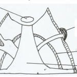
The diagram below shows an upland area.
(a) Name the feature P, Q and R. (3 marks)
(b) How is a u-shaped valley formed? (3 marks)
6 marks
(a) State three ways in which lakes are formed. (3 marks)
(b) Give two characteristics of lakes formed due to faulting. (2 marks)
5 marks
SECTION B (75 Marks)
Answer question 6 and any other TWO questions from this section
Study the map of Busia (1:50,000) sheet 101/1 provided and answer the following
questions.
(a) (i) Give the latitudinal and longitudinal position of South East corner of the map
(2marks)
(ii) Give two methods that have been used to represent relief. (2marks)
(b)(i) What is the length in Kilometres of the All-weather loose surface road (C526) from
the road junction at Odiado to the road junction at Bumula. (2marks)
(ii) What is the bearing of the road junction at Matayo from the air photo Principal
(2 marks)
(iii) Give three social services that are provided at Funyula. (3 marks)
(c) Describe the drainage of the area covered by the map. (6marks)
(d)(i) Apart from trading, name two other economic activities in Busia area. (2marks)
(ii) Citing evidence from the map, explain three factors that favour trading in the area
covered by the map. (6marks)
25 marks
(a)(i) What is folding? (2marks)
(ii) Name one country where the following fold mountains are found.
• Andes (1mark)
• Atlas (1mark)
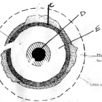
(b) The diagram below shows a types of fold.
Name the features marked x, y and z ( 3marks)
(c) With the aid of a labelled diagram, describe how an overthrust fold is formed.
(6 marks)
(d) Explain four effects of fold mountains on climate (8marks)
(e) Form four students in your school are planning to study land forms through field work.
Give four reasons why it is important to study the folded landforms through fieldwork.
(4 marks)
25 marks
(a) Define the term vegetation (2marks)
(b) Explain how the following factors influences the distribution of vegetation
(i) Aspect (2marks)
(ii) Relief (3marks)
(c)The map below shows world vegetation zone
(i) Name vegetation type marked 1,2, 3, and 4 (4marks)
(d) Explain four ways in which trees in coniferous forests are adopted to the climatic
condition (8marks)
(e)A form four Geography class is planning to carry out a field study in Kakamega forest.
(i) State how they would use the following tools during the study.
– – A tape recorder (1mark)
A sketch map (1mark)
– A camera (1mark)
(ii) Give three methods they would use to collect the data during the study. (3 marks)
25 marks
(a) (i) Differentiate between river catchment and watershed. (2marks)
(ii) Describe three processes by which a river transports its load. (6marks)
(b) Explain three factors that lead to rejuvenation of a river. (6marks)
(c)Describe each of the following drainage patterns.
(i) Centripetal drainage pattern (2marks)
(ii) Superimposed drainage pattern (3marks)
(e) You are to carry out a field study of a river within the vicinity of your school.
(i) State two reasons why you need a working schedule. (2 marks)
(ii) State two characteristics of a river you are likely to observe in its lower course.
(2 marks)
(iii) State two follow up activities you are likely to carry out after the study. (2marks)
25 marks
(a) (i) Name two components of soils. (2 marks)
(ii) State three characteristics of desert soils. (3 marks)
(iii) List two factors that contribute to soil leaching. (2 marks)
(b) Describe how lateralization occurs. (6 marks)
(c) Explain how the following processes occurs.
(i) Splash erosion (2 marks)
(ii) Gulley erosion (2 marks)
(d) (i) What is soil conservation? (2 marks)
(ii) Explain in three ways of maintaining soil fertility. (6 marks)
25 marks


