KNEC KCSE Geography Paper 1 Question Paper / 2016 KCSE MOKASA Joint Examination
2016 KASSU JET JOINT EXAMINATION
Geography Paper 1
SECTION A (25 Marks)
Answer All the questions in this section
(a) State three effects of revolution of the earth. (3marks)
(b) The local time at Tema on 0o longitude is 12.00 noon. Calculate the local time at Hola 40oE. (2marks)
5 marks
(a) What is temperature? (2marks)
(b) Give three factors that determine the amount of solar isolation received on the earth’s surface. (3marks)
5 marks
(a) What are extrusive volcanic features? (2marks)
(b) Apart from basic lava domes, name three other vent eruption volcanic features. (3marks)
5 marks
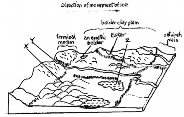
(a) State two conditions that may lead to glacial deposition. (2marks)
(b) The diagram below shows some features formed from glacial deposition in lowland areas. Name the features marked X,Y and Z. (3marks)
5 marks
(a) Give two processes through which wind erodes the desert surface. (2marks)
(b) Describe how a mushroom block is formed. (3marks)
5 marks
SECTION B (75 Marks)
Answer question 6 and any other Two from the remaining.
Study the map of Busia 1:50,000 (sheet 101/1) provided and answer the
following questions.
(a) (i) What is the vertical interval of the area covered by the map? (1mark)
(ii) Give the six figure grid reference of the chief’s house, (2marks)
(iii)What was the magnetic variation of the area when the map was
drawn? (1mark)
(iv) What is the height of Odhiado hill? (2marks)
(b) (i) Measure the distance of the international boundary from point where it
crosses northing 41 to Northing 50 (Give your answer to the nearest 100
meters) (2marks)
(ii) Calculate the area enclosed by river sio, south of Northing 50, west of
all-weather road. Loose surface (B8/3) and East of the international
boundary. (2marks)
(c) (i)Using a vertical scale of 1cm to represent 40 meters, draw a cross section
along Northing 37 from Easting 24 to Easting 31. On the cross-section
mark and name;
• All weather road; loose surface
• River
• Swamp
• Hill
• Riverine trees
(ii)Calculate the vertical exaggeration of the cross section (2marks)
(iii) Determine the intervisibility of the cross section you have drawn.
(2marks)
(d) Describe the drainage of the area covered by the map. (5marks)
25 marks
(a) Identify four causes of earth movements. (4marks)
(b)(i) Name three types of tectonic plate boundaries. (3marks)
(ii) Give four reasons why it is necessary to study the plate tectonic theory. (4marks)
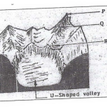
(c)The map below shows the location of some fold mountains ranges.
(i) Name the mountains ranges marked W, X Y and Z (4marks)
(ii) Apart from Fold Mountains, name two other features associated with folding. (2marks)
(iii) Explain four positive effects of Fold Mountains to human activities. (8marks)
25 marks
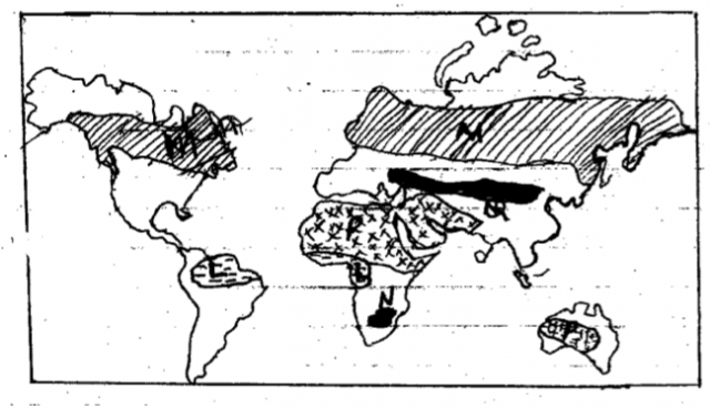
Use the map below to answer question (a) and (b)
(a)(i) Name the:
• Vegetation marked L,M (2marks)
• Grasslands marked N,Q (2marks)
(ii) Identify the type of climate marked P. (1mark)
(b) Explain four ways in which vegetation in the region marked P has adopted
to the climatic conditions. (8marks)
(c)(i) Describe the characteristics of the equatorial climate. (5marks)
(ii) What is climate change? (2marks)
(iii)State two natural causes of climate change. (2marks)
(e) State four consequences of climate change on the physical environment.
(4marks)
25 marks
(a)(i) Distinguish between a river divide and interfluves. (2marks)
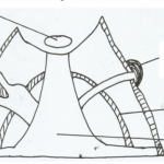
(ii) The diagram below shows the processes of hydrological cycle. Name the
processes marked P,Q,R and S (4marks)
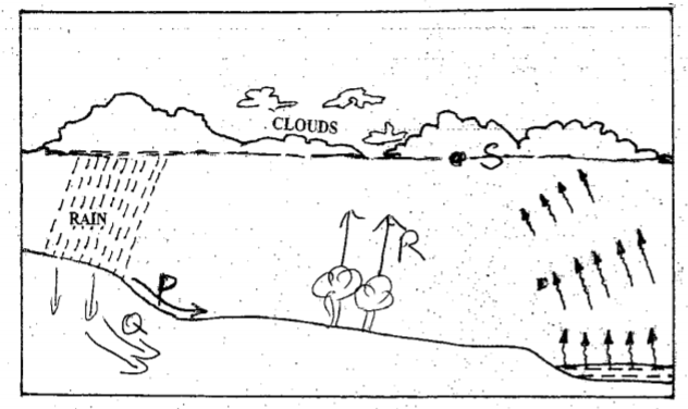
(b) Describe two processes by which a river transports its load. (4marks)
(c) Describe the following drainage patterns:
(i) Superimposed (3marks)
(ii) Dendritic (2marks)
(d)Your class is planning to carry out a field study on a river in its old stage.
(i) Apart from flood plain, name two other features you are likely to identify (2marks)
(ii) State three activities students would engage in during the field study. (3marks)
(iii)Describe three characteristics of the flood plain they would identify. (3marks)
25 marks
(a)(i) Define the term soil profile. (2marks)
(ii) Outline three factors that contribute to the development of soil catena.
(3marks)
(b) Explain how the following factors influence the formation of soil.
• Parent rock (3marks)
• Biotic factors (3marks)
(c) You intend to carry out a field study on the management and
conservation of soil in the area near your school.
(i) Explain how the following influences the characteristics of the soil.
• Irrigation (4marks)
• High temperature (2marks)
(ii) Give three reasons why you are likely to rely on observation as a
method of data collection. (3marks)
(d) Describe laterisation as soil forming process. (5marks)
25 marks
