KNEC KCSE Geography Paper 1 Question Paper / 2015 KNEC KCSE Bomet County Joint Examinations
2015 KCSE Bomet County Joint Examinations
Geography Paper 1
SECTION A (25 Marks)
Answer ALL the questions in this section
(a) Differentiate between equinox and solstice. (2marks)
(b) Name three types of tectonic plates boundaries (3marks)
5 marks
(a)Differentiate between anabatic winds and katabatic winds (2marks)
(b) State three factors that hinder weather forecasting (3marks)
5 marks
(a)State three occurrence of minerals (3marks)
(b) State two layers of atmosphere which experience Negative Lapse Rate. (2marks)
5 marks
(a)What is a longitude? (2marks)
(b) What is the time in Hola 40oE when the time in Accra 0o Longitude is 3p.m? (3marks)
5 marks
(a)State two factors that influence rate of erosion by a river in its upper course (2marks)
(b) State three ways in which waves in Indian Ocean erodes its coast. (3marks)
5 marks
SECTION B (75 Marks)
Answer question 6 and any other TWO questions in this section.
(a)Name two type of natural vegetation in North of Northing’s 83 (2marks)
(b)Citing evidence from the map explains three factors that favoured the establishment of Mutitu
(Ndooa) Town in the area (6marks)
(c )Using a scale of 1cm represent 100metres. Draw across-section from point x(080660 to
Y(130660) (4marks)
On the cross-section mark and label the following.
(i)Road (1mark)
(ii)Water pipe line (1mark)
(iii)Rivers on the East of Easting 10 (1mark)
(iv)Calculate vertical exaggeration of cross-section. ( 2marks)
(d)Describe the settlement of area covered by map on East of Eastings 07 (3marks)
(e)Mention Latitude and Longitude of point B at gride reference 988620 (2marks)
(f) Citing evidence from the map, state three economic activities carried out in area carried by
the map (3marks)
25 marks
The diagram below represents a well developed soil profile. Use it to a answer question
(i) Describe the characteristics of Horizon B ( 3marks)
(ii)A part from humus, name three other components of soil. (3marks)
(iii) State three ways in which humus contributes to the quality of soil. (3marks)
(b) (i)Differentiate between soil structure and soil texture. (2marks)
(ii) Explain how the following factors influence soil formation:
Topography (6marks)
Time (2marks)
(c) Explain how the following farming practices may lead to loss of soil fertility.
(i) Overgrazing (2marks)
(ii) Frequent ploughing (2marks)
(iii) Continuous irrigation (2marks)
25 marks
(a) Describe plucking as a process in glacial erosion (4marks)
(b) Explain three conditions that lead to glacial deposition. (6marks)
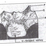
(c)(i) Name three main erosional features in glaciated highlands (3marks)
(ii) Describe how terminal moraine is formed. (4marks)
(d) Explain four positive effects of glaciations in low land areas. (8marks)
25 marks
(a)(i) Define the term Aridity (2marks)
(ii) Name three types of deserts in term of appearance (3marks)
(b) List two factors that contribute to the development of deserts. (2marks)
(c)Explain three factors influencing wind transportation (3marks)
(d) Describe how the following desert features are formed.
(i) Rock pedestal (3marks)
(ii) Zeugen (3marks)
(e) State any six significance of desert feature to human activities. (6marks)
22 marks
.(a)(i) Name two major earthquake zone s of the world. (2marks)
(ii) Differentiate between an intrusive volcanic feature and extrusive volcanic feature. (2marks)
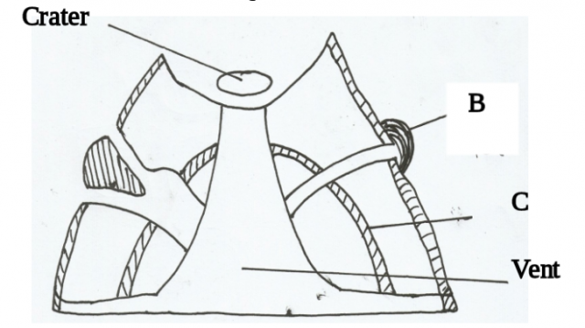
Use the diagram below to answer the question that follows:
Identify the type of volcano represented above (1mark)
Name the parts marked B,C (2marks)
Describe how the above volcanic feature is formed. (4marks)
(c) List and explain the three life cycles of a volcano. (6marks)
(d) State four importance of volcanicity to human environment. (4marks)
(e) Students from your school carried out a field study on volcanicity within the district.
(i) State two objectives of their study. (2marks)
(ii) What problems did they encounter during the field study . (2marks)
25 marks

