KNEC KCSE Geography Paper 1 – 2014 Gatundu Mock
2014 Gatundu Mock
Geography Paper 1
SECTION A (25 Marks)
Answer all questions in section A.
(i) Differentiate between weather and climate. (2 marks)
(ii) Outline any three factors that are considered in locating a weather station. (3 marks)
(iii) Give any three importance of weather focusting. (3 marks)
8 marks
(i) Define the term equinox (2 marks)
(ii) What is the time at Hola on 40oE when the time at Tema on Oo longitude is 12.00 Noon?(2 marks)
4 marks
(i) Name two types of earth movements that take place on the earth crust. (2 marks)
(ii) Describe the origins of the continents according to the theory of continental drift. (3 marks)
5 marks
(i) Name two types of clouds that give rise to rainfall in tropical regions. (2 marks)
(ii) Define the term hydrological cycle. (2 marks)
4 marks
(a) Study the table below and answer the question.
| Month | J | F | M | A | M | J | J | A | S | O | N | D |
| Temperature oC | 29 | 28 | 30 | 30 | 29 | 29 | 29 | 27 | 29 | 30 | 30 | 28 |
| Rainfall in mm | 10 | 9 | 22 | 48 | 26 | 9 | 24 | 0 | 5 | 10 | 18 | 11 |
(i) Calculate the mean annual rainfall. (1 mark)
(ii) What is the annual range of temperature? (1 mark)
(iii) Give two reasons why the top of Mt. Kenya has got no vegetation. (2 marks)
4 marks
SECTION B (75 Marks)
Answer question 6 and any other two questions.
Study the map of Karatina 1:50,000 (sheet 121/3) provided and answer the following questions.
(i) What is the longitudinal extent of the map: (2 marks)
(ii) Name the two districts from where the map has been taken from. (2 marks)
(iii) What is the approximate height of the hill at grid reference 047507? (1 mark)
B. (i) Give three types of natural vegetation found to the north of northings 60. (3 marks)
(ii) What is the approximate area of Karatina town (municipality) (2 marks)
(iii) Measure the approximate distance of the district boundary not covered by the forest. (2 marks)
(iv) Citing evidence from the map, identify two main cash crops grown in the area covered by the map.
(2 marks)
C. (i) Citing evidence from the map, explain three factors that favours tea growing in the area covered by
the map. (6 marks)
(ii) Describe the drainage of the area covered by the map. (5 marks)
25 marks
(a) (i) Define the term faulting? (2 marks)
(ii) State any two characteristics of lakes formed due to faulting. (2 marks)
(iii) With the help of a well labeled diagram, explain how the rift valley is formed through tension.
(7 marks)
(b) A group of students carried field work in the rift valley around Naivasha.
(i) Give any four preparations that they undertook. (4 marks)
(ii) Give any two reasons why it would be appropriate to divide the students into groups. (2 marks)
(iii) Explain any four importance of faulting to human activities. (8 marks)
25 marks
(a) What is a lake. (2 marks)
(b) (i) Name two types of lake formed due to volcanicity. (2 marks)
(ii) Explain how Lake Victoria influences the climate of the surrounding area. (6 marks)
(c) (i) State three main reasons why lakes within the Rift Valley are salty. (3 marks)
(ii) Name any three fresh water lakes in Kenya which are within the Rift Valley. (3 marks)
(d) (i) Explain any four economic significances of lakes to human activities. (8 marks)
(ii) Give one negative effect of lakes to man. (1 mark)
25 marks
(a) (i) Give two ways in which underground water may reach the earth’s surface. (2 marks)
(ii) State three conditions necessary for the formation of artesian wells. (3 marks)
(b) Explain three importance of underground water. (6 marks)
(c) (i) Give three factors which influences the development of Karst landscape. (3 marks)
(ii) Explain three reasons why Karst landscape discourages settlement. (6 marks)
(e) With an aid of a well labeled diagram describe the formation of a limestone pillar. (5 marks)
25 marks
(a) Outline three processes through which ice moves. (3 marks)
(b) Explain three factors that influence glacial erosion. (6 marks)
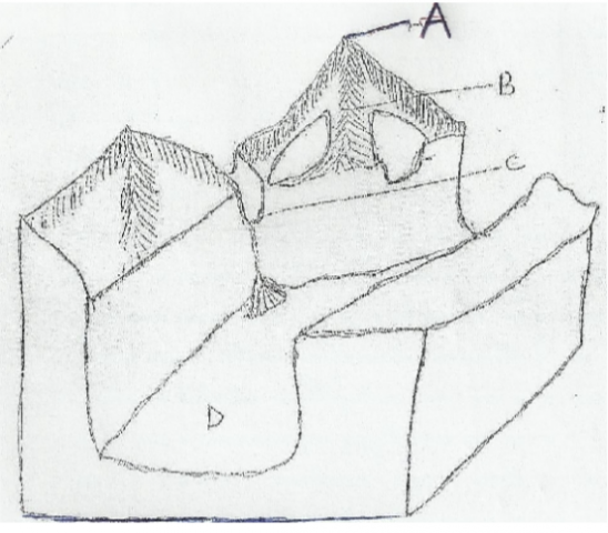
(c) Study the diagram below which shows a glaciated highland and answer questions c (i) and (ii)
(i) Name the features marked A, B, C and D. (4 marks)
(ii) Describe how features A and D were formed. (6 marks)
(d) Suppose you were to carry out a field study of a glaciated highland:-
(i) State two disadvantages of using observation as a method of data collection. (2 marks)
(ii) State two problems you are likely to encounter. (2 marks)
(iii) Suggest two economic activities you would recommend to the Government in this area.(2 marks)
25 marks
