2014 Cross Country Mock
Geography Paper 1
SECTION A (25 Marks)
Answer all questions in this section
(a) Define the term orbit (1mk)
(b) The diagram below shows the internal structure of the earth. Use it to answer the questions that
follow.
(i) Name the zone of discontinuity marked X. (1mk)
(ii) State three characteristics of the part marked Y. (3mks)
5 marks
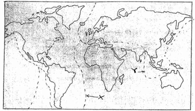
Use the world map below to answer question (a)
(a) Name the tectonic plate boundary marked X and Y. (2mks)
(b) What is the importance of studying the plate tectonics theory? (3mks)
5 marks
(a) Apart from normal faults, name two other types of faults. (2mks)
(b) Describe three distinctive characteristics of the Rift Valley. (3mks)
5 marks
The diagram below shows mass movement on a slope. Use it to answer question (a).
(i) Name the type of mass movement shown. (1mk)
(ii) Name the part marked U. (1mk)
(b) State three negative effects of mass wasting in Kenya (3mks)
5 marks
(a) What is underground water (1mk)
(b) Give two main sources of underground water (2mks)
(c) The diagram below shows an artesian basin. Name the parts marked X and Y. (2mks)
5 marks
SECTION B (75 Marks)
Answer question 6 and any two other questions from this section.
Study the map of Nkubu (1:50,000) sheet 122/1 provided and answer the following questions.
(a) (i) Give the six-figure reference of the trigonometrical station at Gatimbi. (2mks)
(ii) Give the latitudinal extend of the are covered by the map. (2mks)
(iii) What is the length in kilometers of the all-weather bound surface road junction at Getuaga to
the road junction at Gatimbi? (2mks)
(iv) What is the approximate height of the peak of Kirui hill? (2mks)
(b) Explain three factors which have influenced the distribution of settlements in the area covered by the map. (6mks)
(c) Draw a rectangle 15cm by 10cm to represent the area covered by the map. (1mk)
On the rectangle, mark and name;
(i) Rurie swamp (1mk)
(ii) Forest (1mk)
(iii) River Muugi (1mk)
(d) (i) Citing evidence from the map, give two reasons why the area covered by the map is suitable
for coffee growing. (4mks)
(ii) Apart from agriculture, name three other economic activities carried out in the area covered
by the map. (3mks)
25 marks
(a) (i) What is a rock? (2mks)
(ii) Explain the process of formation of mechanically formed sedimentary rocks. (5mks)
(iii) Give three examples of mechanically formed sedimentary rocks. (3mks)
(b) Explain three ways in which rocks are significant to the economy of Kenya. (6mks)
(c) Students from your school carried out a field study on the type of rocks.
(i) One of the rock samples they collected is coral. Give three uses of this type of rock (3mks)
(ii) Give three types of information for their study. (3mks)
(iii) State three problems they are likely to have encountered during the field study. (3mks)
25 marks
(a) (i) Distinguish between catchment area and a drainage basin. (2mks)
(ii) Explain three factors which influence the ability of a river to transport its load. (6mks)
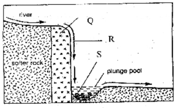
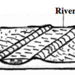
(iii) The diagram below shows a feature formed by erosion along the river course. Name the parts
marked Q, R and S. (3mks)
(b) (i) What is a delta? (1mk)
(ii) Draw a diagram to show an arcuate delta. (4mks)
(iii) Name one river in Northern Kenya which forms a birds foot delta. (1mk)
(c) Students from your class carried out a field study on a nearby river to study various features along its course.
(i) Give four reasons why the class was divided into groups. (4mks)
(ii) Give four follow-up activities you were involved in after the field study. (4mks)
25 marks
(a) (i) What is glaciation? (2mks)
(ii) Explain three factors that influence the rate of glacial erosion. (6mks)
(b) (i) Apart from cirques, name two other erosional features found in glaciated highlands. (2mks)
(ii) With the aid of a well labeled diagram, describe how a cirque is formed. (7mks)
(c) Explain four positive effects of glaciation in lowland areas. (8mks)
25 marks
(a) What is natural vegetation? (2mks)
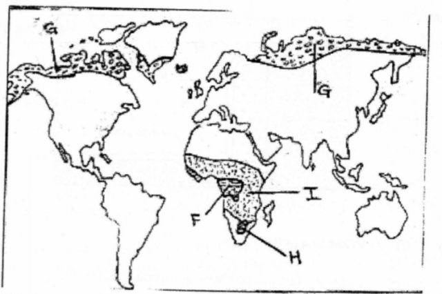
(b) The map below shows some vegetation regions of the world. Use it to answer the questions that
follow.
Name:
(i) The type of vegetation found in the are marked F and G. (2mks)
(ii) The grassland found in the area marked H (1mk)
(iii) Describe the characteristics of the natural vegetation found in the shaded are marked I
(4mks)
(c) (i) draw a well labeled diagram to show soil catena (4mks)
(ii) Explain how the following farming practices cause soil erosion
Monoculture (2mks)
Overstocking (2mks)
(d) (i) State two factors that contribute to soil leaching. (2mks)
(ii) Explain three ways in which vegetation prevents soil erosion. (6mks)
25 marks

