KNEC KCSE Geography Paper 2 Question Paper / 2014 Kakamega County Mock
2014 Kakamega County Mock
Geography Paper 2
SECTION A (25 Marks)
Answer all the questions in this section.
(a) Name two navigable rivers in Africa. (2 marks)
(b) State three reasons why river transport is less developed in Africa. (3 marks)
5 marks
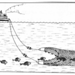
The diagram below shows a method of fishing. Use it to answer the questions that follow.
(a) Identify the method of fishing shown in the diagram. (1 mark)
(b) Describe how the method is used to catch fish. (4 marks)
5 marks
(a) Name two areas where gold is mined in the Republic of South Africa. (2 marks)
(b) State three contributions of gold mining to the economy of the Republic of South Africa. (3 marks)
5 marks
(a) State three factors that have promoted the establishment of national parks in Kenya. (3 marks)
(b) Apart from establishment of game reserves and national parks, give two other methods of wildlife
conservation in Kenya. (2 marks)
5 marks
(a) Define the term forestry. (1 mark)
(b) Givefourfunctions of forests. (4 marks)
5 marks
SECTION B (75 Marks)
Answer question 6 and any other two questions from this section.
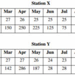
The table below shows the values of Kenya’s imports in million shillings between the years 2005 –
2009. Study it and use it to answer question (a)
(a) (i) Using a vertical scale of 1cm to represent Kshs 5 billion, draw a comparative line graph to
represent the above information. (8 marks)
(ii) Other than comparative line graphs, name one other statistical methods that can be used to
represent the above data. (1 mark)
(b) Explain three measures that can be used to correct the unfavourable balance of trade in Kenya
(6 marks)
(c) (i) Give two factors that promote internal trade in Kenya. (2 marks)
(ii) State three problems facing internal trade in Kenya. (3 marks)
(d) (i) Name two trading blocs in Africa of which Kenya is a member. (2 marks)
(ii) State three benefits of trading blocs to the economies of African countries. (3 marks)
25 marks
(a) (i) Define the following terms. A factory (1 mark) Industrialization (1 mark)
(ii) Give three reasons why the government of Kenya encourages industrialization in the country. (3 marks)
(b) (i) Name two products of cottage industry in Kenya (2 marks)
(ii) State three characteristics of the cottage industry in India (3 marks)
(c) (i) Give two reasons why primary industries are located close to the raw materials. (2 marks)
(ii) Name three examples of secondary industries in Kenya. (3 marks)
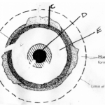
(d) The diagram below is a map of the Ruhr Industrial region of Germany. Study it and use it to answer
the questions that follow.
(i) Name the rivers labeled A and B (2 marks)
(ii) Name the industrial areas marked X and Y (2 marks)
(iii) Explain three factors that led to the development of Iron and Steel industries in the Ruhr
region of Germany. (6 marks)
25 marks
(a) (i) Define the term transhumance. (2 marks)
(ii) State four characteristics of nomadic pastoralism. (4 marks)
(b) (i) Name three dairy breeds kept in Kenya. (3 marks)
(ii) Explain four conditions favouring dairy farming in the Kenyan highlands. (8 marks)
(c) (i) State four limitations of beef farming in Kenya. (4 marks)
(ii) Give four similarities between beef farming in Kenya and Argentina. (4 marks)
25 marks
(a) (i) Name two primary sources of population data other than census. (2 marks)
(ii) State three reasons why a country should conduct regular censuses. (3 marks)
(b) Explain how the following factors influence population distribution
(i) Climate (3 marks)
(ii) Industrialization (2 marks)
(c) Figure below shows the age – sex pyramid of a given country. Use it to answer the questions
that follow.
(i) State four characteristics of the population represented in the age – sex pyramid. (4 marks)
(ii) What type of country is likely to be associated with the above age – sex pyramid? (1 mark)
(iii) State two advantages of using age – sex pyramids in representing population data (2 marks)
(d) Explain four problems of overpopulation in developing countries. (8 marks)
25 marks
(a) (i) Define the term land reclamation . (1 mark)
(ii) State four benefits that have resulted from the reclamation of Yala swamp. (4 marks)
(b) The diagram below shows the distribution of irrigation schemes in Kenya. Use it to answer the
questions that follow.
(i) Name the irrigation schemes labeled Q and R. (2marks)
(ii) Name the river marked M (1 mark)
(iii) Explain four physical factors that favoured the establishment Perkerra Irrigation Scheme
(8 marks)
(c) State four problems facing irrigation farming in Kenya. (4 marks)
(d) (i) What is a polder? (1 mark)
(ii) Give two differences between land reclamation in Kenya and Netherlands (4 marks)
25 marks


